


News
13.10.2022
Delivery of NavVis VLX 2nd Generation Mobile Scanner
Engineering Surveys have recently taken delivery of a 2nd Generation NavVis VLX Mobile Scanning System and have put it to work on two current projects. The results to date are extremely impressive both in terms of the absolute point cloud accuracy and the resolution achievable in a short observation period. The “richness” of the point cloud and lack of noise makes the output extremely easy to use for Scan to CAD or Scan to BIM applications…… More to follow.
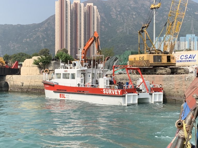
10.02.2020
ESL Survey 2 arrives in Hong Kong
After 18 months Design and Construction in Guangzhou “ESL Survey 2” has been delivered. With a 40 square meter back deck, multiple sensor mounts and launch/recovery systems this vessel allows ESL to deploy a wider range of survey systems than could be accommodated on ESL Survey 1. Our first boat shall still be used for shallow water surveys while “Survey 2” shall be utilised where multiple sensor options such a Multi-Beam, UAV Photogrametry and Laser Scanning are required. More to follow…
30.11.2018
RICS/HKIS Mutual Recognition now restarted
RICS and the Hong Kong Institute of Surveyors (HKIS) jointly announce a mutual recognition of membership for professionals of the two organisations today (29 November). The mutual recognition is applicable to professionals from geomatics professional group. Details of the recognition are as follows. HKIS members to admit as RICS professionals Corporate members of the Land Surveying Division of HKIS (FHKIS and MHKIS) may upon application to RICS be admitted as a professional member of RICS (Chartered Land Surveyor (MRICS)) and be a member of the Geomatics Professional Group, and may be entitled to all the privileges of RICS membership subject to: a. one year post-qualification as a Corporate member of the Land Surveying Division of HKIS and professional practice relevant to the geomatics profession; and b. the successful completion of the RICS ethics assessment prior to admission; c. a professional interview conducted at the discretion of RICS to verify the applicant’s competence and suitability for admission to the Geomatics Professional Group. RICS professionals to admit as HKIS members Professional members of RICS (FRICS and MRICS) qualified as a Chartered Land Surveyor, whose principal place of practice being in Hong Kong may upon application to HKIS be admitted as a professional member of HKIS (MHKIS) in the Land Surveying Division, and may be entitled to all the privileges of HKIS membership, including the use of the designation of professional surveyors and the designatory letters, subject to: a. one year post-qualification as a Chartered Land Surveyor and professional practice in Hong Kong relevant to the Land Surveying Division of HKIS; and b. a professional interview conducted at the discretion of HKIS to verify the applicant’s competence and suitability for admission to the Division. This mutual recognition of membership does not apply to any corporate member of the Land Surveying Division of HKIS, or the Geomatics Professional Group of RICS whose admission to membership is by virtue of a reciprocity agreement with another professional body. This mutual recognition of membership offers a streamlined application process for professional surveyor membership qualifications which will allow surveying professionals to practise in both local and global markets, and ultimately benefit their portfolio and raise their professional standing worldwide. For details and enquiries of admission, please contact RICS office in Hong Kong at e: ricshk@rics.org or t: +852 2537 7117; or HKIS office at e: memdept@hkis.org.hk or t: +852 2526 3679. Clare Chiu Chief Operating Officer, Greater China
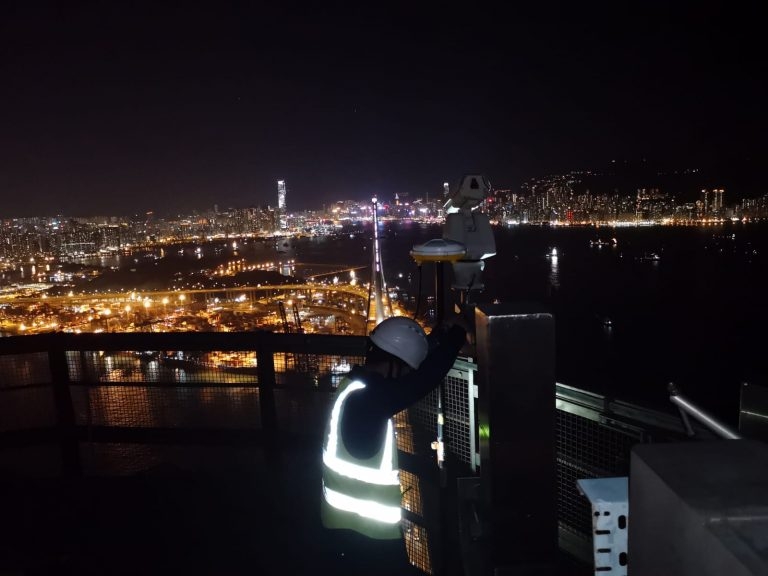
31.10.2018
Stonecutters Bridge Configuration Survey
Edward and Mike carried out the SCB Tower Top GNSS configuration survey on 30th Oct 2018. It was a beautiful night with little pollution as can be seen from the photo below.
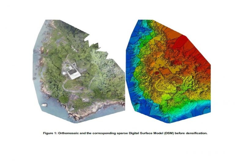
30.10.2018
Green Island UAV Reality Capture and Laser Scanning
ESL have recently completed the data capture for the Green Island Heritage Site. This involved the integration of UAV photogrammetry and Laser Scanning. Following receipt of CAD flying permit data capture for both Aerial and Terrestrial was completed in 4 days. Production of BIM Model is now ongoing.
26.07.2018
Commissioning of new USM Mount
Our Hydrographic Team have successfully commissioned and tested a new Universal Sonar Mount (USM) using a Reson TP-50 multibeam with Octans 3000 IMU and Trimble GNSS.
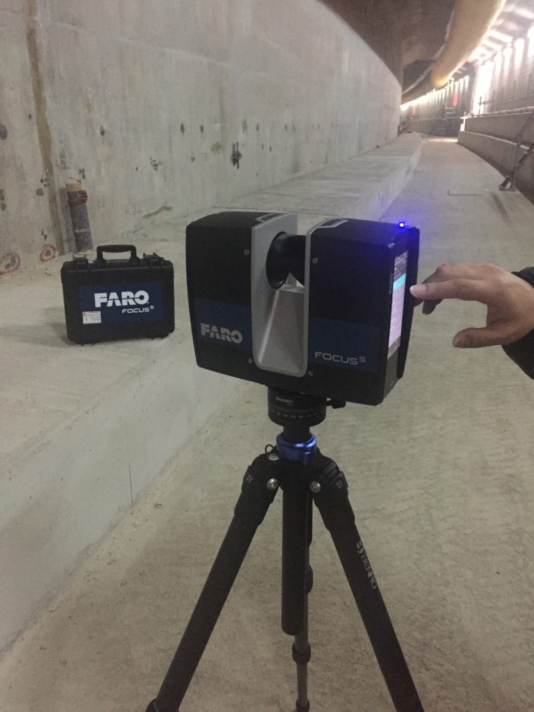
16.03.2018
Delivery of new Faro S150 Laser Scanner
Our new Faro S150 Laser Scanner has arrived and has been put to work. It’s small size and mobility complements our Leica P20 scanner which together with our Faro Freestyle gives us great flexibility in choosing the right tool for the job. Laser Scanning and scan to BIM is currently a growing market sector for ESL.
30.01.2018
Contract 1121 progress celebration
Element E11 prior to sinking with “ESL Survey 1” alongside.
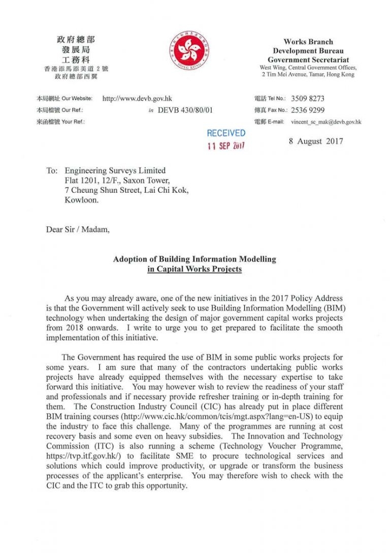
10.11.2017
HK Government pushing the adoption of BIM
15.10.2017
Construction in 2020 – what does it mean for Surveyors
Please read the article below from the US construction firm “Bechtel” http://www.bechtel.com/about-us/innovation/project-2020/ They predict that construction will move towards automation by 2020 with the adoption of AI and drones driving this change. Such sensors rely on precise Geospatial positioning which is extremely positive for companies like our own.